Blog


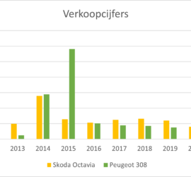
Hoe de bijtelling de autoverkoop stuurt

Wat is bijtelling? Als een werknemer voor zijn werkgever een auto beschikbaar gesteld krijgt, die hij of zij ook privé gebruikt (vanaf 500 km per jaar) , dan ziet de fiscus dit als een soort van salaris. Daarom wordt een fictief bedrag (de bijtelling) bij het salaris opgeteld, waarover loonheffing […]


Displaying your position in a Leaflet viewer

A colleague asked my whether it would be possible to view the current location of a user in a Leaflet-based GIS viewer. Luckily, this is very easy to do, as explained in this tutorial. All you need to add to the code of my previous example is the following code: […]


Computing the accuracy of GNSS baselines

When designing a surveying network, it is important to know the accuracy of your observations in order to get a realistic estimate of the accuracy that can be achieved for the coordinates. For traditional observations such as total stations angles and distances, we usually rely on manufacturer specifications and experience. […]


Creating a map of Covid cases per municipality in QGIS

Since the beginning of Covid-19, I’ve from time to time downloaded the official Dutch Covid-19 statistics (available here) and created my own plots, using a Jupyter Python notebook that you can find over on Github. But it’s also interesting to view maps instead of only timeline plots. Unfortunately, the official […]


GNU Octave

During my studies in geodesy and surveying, we did a lot of linear algebra computations, as adjustment theory requires matrix computations. Naturally, Matlab was used a lot – although I preferred to stick with C++ most of the time, which necessitated writing my own matrix library. But there’s no denying […]


Notepad++

A decent text editor is one of the most important programs on your computer. I use it for coding, for looking at the results, and sometimes simply for taking notes. Since Windows still only comes with crappy Notepad, you need to find something else. Luckily, there’s Notepad++, a free text […]